Monitoring ground deformation from space
When Galileo looked through his telescope for the first time, could he imagine all the changes that he had just paved the way for? 400 years later, mankind would be able to explore the solar system, map the stars, walk on the moon and learn a lot about its own planet, the Earth.
It is maybe on that last point that the value brought by the development of the space industry is the most tangible: satellites have allowed to monitor the earth like never before. With the invention of re-usable rockets, satellites deployment is becoming cheaper, and their data accessible to more and more users. Civil Engineering is one of the fields that could yield the biggest benefits from that democratization of satellite data.
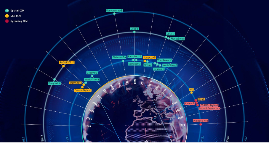
You may wonder what the link between a dam, or a road construction project, and satellite data could be. This is because you haven’t heard of InSAR yet. The Interferometric Synthetic Aperture Radar (InSAR) technology allows to monitor ground deformation from space. By measuring the travel time of radio waves emitted by a SAR satellite and reflected by the earth, and monitoring their evolution through the days, the uplift of ground and surface infrastructures, or their subsidence, can be measured with millimetric precision. The uses of that data are numerous, and range from dam monitoring to infrastructure planning, or quantification of the impact of underground projects.
With the apparition of new constellations, and the widening of satellite data’s usage, the InSAR market is booming. This growth poses a major challenge to all market incumbents: how can we ensure that we bring out the best of InSAR’s value for diversified new clients? How can we ensure scaling capabilities to meet an exploding demand?
AI brings the best out of the InSAR technology
Within that highly technical and competitive market, one player, Sixense Satellite – the satellite unit of the VINCI group -, chose to resort to AI to face those challenges, and joined Leonard’s AI program.
The pursue of AI within Sixense Satellite was brough by two targeted needs:
- First, a greater automation of the processing pipeline: deriving millimetric precision deformation map from raw radio waves captured by satellites requires the use of complex algorithms.
- Second, advanced analytics products to help focus on the most relevant deformations in the area: as InSAR can deliver massive information on an area’s deformation, busy clients need some help to concentrate only on the most relevant part of the captured data.
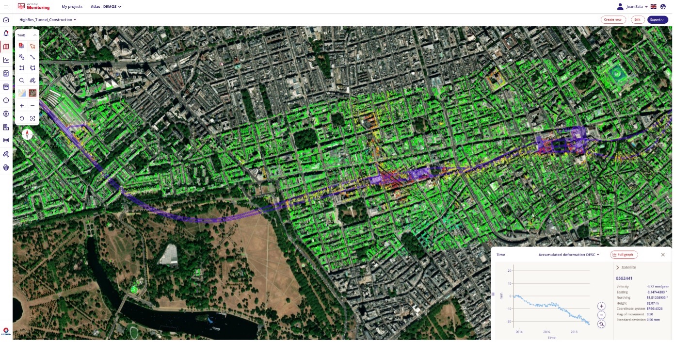
Sixense chose to start its processing pipeline automation with the cumbersome quality control task, and thanks to the combination of several computer vision techniques, it was able to create an advanced automated system.
In parallel, Sixense also implemented several algorithms that will analyze the deformation data itself and help the client focus on the most critical deformation zones to monitor. A second objective was to target those active deformation areas that may not be blindingly obvious (e.g – seasonal patterns). As a result, clients are now able to identify within seconds the most relevant information brought by the massive amounts of InSAR data.
What’s next?
How best to ensure the value and adoption of innovation than testing it on the field? This is precisely what Sixense did by directly developing its solutions with its project partner VIA-IMC. To raise awareness about the latest advances, Sixense Satellite will also present some of these works at the International Symposium on Field Monitoring in Geomechanics (ISFMG).
Anticipating climate change impact, extending infrastructures lifespans, and reducing the carbon footprint of monitoring systems have become urging concerns. InSAR, as a fully remote and non-invasive solution, can efficiently tackle these challenges. Thanks to AI and the improvements Atlas InSAR, some major steps have been taken in that direction.
The algorithms developed in the AI program have been a joint effort of an amazing team composed by Joan Sala and Amalia Vradi from Sixense Iberia.
This article is part of a series involving the participants of the AI program by Leonard, the VINCI Group’s foresight and innovation platform. The program has been specifically designed to accelerate the adoption of AI technologies within VINCI. It consists in a five-month incubation period where selected VINCI collaborators follow a learning by doing process where they codevelop an AI-based use case under the coaching and mentoring of Leonard’s team and consultants from eleven strategy
More about Leonard’s AI program: https://leonard.vinci.com/en/programmes/ia-course/